


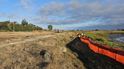
A shoreline defence can be more than a wall. In Palo Alto, California, engineers have built a broad, gently sloping landscape designed to protect the coast while functioning like a living ecosystem. The project sits along Harbor Marsh in the Palo Alto Baylands and combines native vegetation, treated wastewater and a nature-based approach to sea-level rise. Unlike a conventional concrete or steep-sided levee, the new structure is designed to provide habitat as well as help reduce the effects of waves and rising water.According to the City of Palo Alto, the completed project is a 500-foot-long horizontal levee and the first of its kind on the San Francisco Bay shoreline to use treated wastewater from the city’s Regional Water Quality Control Plant to irrigate native plantings. The project was completed in September 2026 after construction began in 2025.
What is a horizontal levee?
A traditional levee typically creates a relatively steep barrier between a community and the water. A horizontal levee takes a different approach. Instead of relying primarily on a hard wall, it uses a wide, gradual slope planted with vegetation. The Palo Alto project is intended to create a transition between upland areas and the existing tidal marsh. Its vegetation includes freshwater marsh, wet meadow, riparian scrub and other native habitat types. As sea levels rise, this broad transition zone can give marsh vegetation space to move gradually uphill rather than ending abruptly at a fixed barrier. The design is therefore intended to serve several purposes at once: improve habitat, help the shoreline adapt to rising seas, reduce wave impacts and provide a way to further treat already-treated wastewater.
Turning treated wastewater into a resource
One of the project’s most unusual features is its use of treated wastewater. Palo Alto’s Regional Water Quality Control Plant produces highly treated wastewater. Instead of allowing all of that water to serve only as a conventional discharge, the horizontal levee uses it underground to irrigate plants growing on the slope.According to the City of Palo Alto, this water is replacing freshwater that historically reached the Baylands through local creeks but was later reduced or cut off because of flood-control channelisation and urban development. As the treated water moves through the soil beneath the planted slope, the system can also provide additional “polishing” treatment before the water reaches the Bay. This creates a circular approach in which water that has already undergone treatment becomes part of a habitat-restoration and climate-adaptation project.
Restoring a missing habitat zone
The levee is also intended to restore a type of habitat that has become increasingly rare around the San Francisco Bay shoreline. The area between freshwater and tidal salt marsh can support a variety of plants and provide important transitional habitat for wildlife. Palo Alto’s project is designed to restore these conditions around Harbor Marsh, potentially benefiting species that use the surrounding wetlands, including the endangered Ridgway’s rail and salt marsh harvest mouse.The project is not simply about planting vegetation. Researchers will monitor how the soil develops, how plants establish themselves and how the ecosystem changes over time. The goal is to determine whether the living slope can continue functioning as sea levels rise.
A test for future Bay Area defences
The word “pilot” is important to the project. Palo Alto is treating the 500-foot structure as a real-world experiment that can provide data for future shoreline projects. Scientists and agencies, including the U.S. Geological Survey, University of California Davis, California State University Channel Islands and the San Francisco Estuary Partnership, are involved in studying its performance. They will examine vegetation, soil accumulation, ecosystem complexity and habitat suitability. The idea is that lessons from this relatively small project could eventually influence larger shoreline-defence schemes around the Bay.Palo Alto’s approach reflects a broader shift in thinking about coastal protection. As sea levels rise, communities increasingly have to protect infrastructure without sacrificing the ecosystems that surround it. The horizontal levee attempts to address both challenges simultaneously: instead of separating the city from nature with a hard barrier, it uses a planted landscape to make the shoreline more resilient. If the pilot performs as intended, this 500-foot stretch of living shoreline could become a model for how other Bay Area communities approach the difficult task of preparing for a higher sea.